(Above) The railway reached Exeter in 1844, providing a vital link to Bristol and London and eventually to the once-small coastal towns of Devon via the Riviera Line.
The Riviera Line is situated in the South West of England and serves the coastal towns of Devon between Exeter St. David’s and Paignton with lines such as the Kingswear or Brixham branches, serving smaller towns throughout Devon.
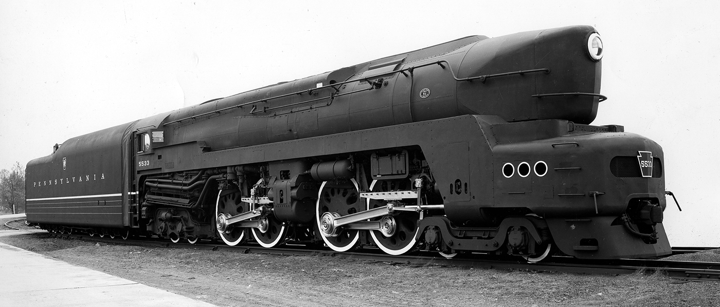
Behind the scenery of this route lies the fascinating history of some of England’s most picturesque locations, from the classic architecture to the vast and unique terrain. Discover more about the Riviera Line in the Fifties route below, featuring 5 fantastic GWR steam locomotives and available now exclusively with Train Simulator 2016.
Exeter
Located on the River Exe in the heart of Devon, Exeter dates back as early as 250 BC where evidence shows possible trade connections with the Mediterranean, early settlements could have been based quite near the River Exe. Military forts used by the Romans were converted for civilian use around 75 AD, from which the foundation of civilisation were based on, expanding in a north-easterly direction. The area in and around Exeter showed evidence of an industry-heavy Roman settlement including pottery, livestock, crops, bronze and copper workings.
The industry side of Exeter continued right through the medieval times despite the attacks and takeovers from the Vikings and the Normans, with weekly markets beginning around the early 1200s to serve the locals and by the end of the century, Exeter enjoyed a tri-weekly market, the only one in the south west of England. One sign that Exeter was fairly developed early on was the impressive aqueducts that served the entire city with fresh drinking water, the water originated from springs in St. Sidwells and reached Exeter by means of subterranean passages, these remarkable water routes lasted into the early 1900s.
Producing products based on the agricultural nature of the area, and with a locally accessible, fast-flowing river to provide power, business boomed for Exeter during the early stages of the Industrial Revolution, this would not last however. When steam power was introduced in the 1800s, Exeter’s development ceased as its location was too far away from any reliable coal resources, the city became less and less important for industry, and avoided the expansion seen by almost every other major town and city in Europe.
Exeter was first reached by the railway in 1844 by the means of the Bristol and Exeter Railway, which not only connected these two cities, but gave them a direct link to London. The South Devon Railway was next to be constructed, extending southwest connecting Exeter to Plymouth via Newton Abbot. Both of these lines were built using Brunel’s preferred 7ft Broad Gauge, however this was eventually converted to standard gauge which is quite obviously, still in use today.
Dawlish
Where the town of Dawlish resides today, people like salt makers or fisherman may have regularly travelled from further inland to gather resources for their industries, in particular salt makers which would make and store their produce around the area. It is thought that these salt makers would eventually move their business to Teignmouth, as the Dawlish Water can be very unpredictable during flooding.
Early settlements started to grow around a mile away from the coast, however nothing really happened until the end of the 18th Century when the wealthy began to make the south coast their summer holiday destination, this transformed Dawlish from a quaint fishing village into an increasingly popular and growing holiday location. One of the more impressive developments for Dawlish was its landscaping performed in the early 19th Century, this included straightening the stream, which has remained in place to this day.
The original railway to pass through Dawlish was not only Broad Gauge, but the South Devon Railway was also designed without conventional locomotives in mind. Instead, the atmospheric railway design was used, this meant air pressure is used to propel a train rather than a locomotive, and it was thought this would prove beneficial in regards to operating along the hilly route, but in fact was teeming with problems and swapped for conventional stock a year after service.
Newton Abbot
Much like Exeter, the origins of Newton Abbot can be found sprouting from the area surrounding a military site, in this instance the village began to grow around Motte-and-bailey castle, built by the Normans, this castle would have most likely been used as a lookout post for the Teign estuary, another settlement was also developing around this time surrounding the River Lemon. The real growth of the town started was when the regular markets began around 1250, the lower settlement near the River Lemon was renamed to Newton Abbot around 1300, with the castle-bearing settlement taking the name of Newton Bushel.
By the mid-1600s, both markets were large enough that they were combined, with many more appearing in the following centuries, to make enough room for all of them, part of the River Lemon was covered over and now flows through a tunnel under Newton Abbot. There has been a continuous, thriving market in Newton Abbot for roughly 700 years, this has naturally seen development of a very industrial nature, produce such as clay, wool and leather, and a canal was built to connect Newton Abbot with Teignmouth port, where regular trade with Newfoundland occurred.
The railway played a vital role to Newton Abbot’s development when it arrived in 1846, in particular it rapidly grew the trade opportunities and the town was no longer bound by the likes of just wool and leather and quickly became an industrial hot zone, a branch line connected Newton Abbot and Torquay a couple of years later. The GWR managed to turn Newton Abbot into a job haven in 1876 when they decided to base their locomotive repair and maintenance sheds adjacent to the station, 600 jobs were initially created, with well over 1000 workers some decades later.
Paignton
Paignton started out as a small Anglo-Saxon Settlement known as Paega’s town, and was documented as Peyton in 1086’s Domesday Book. By 1294, the town became a borough with the introduction of a regular market and fair. Until the 19th Century, Paignton was, like many other coastal settlements in the area, a rather small fishing town, this was until a new Harbour was built in 1837 which saw a growth in the area.
The Dartmouth and Torbay Railway built a line that opened to passengers in 1859, providing a direct link from Paignton and Torquay into London, this would further increase the growth as fishing town, but also provide the wealthy from the Capital with another potential summer holiday destination. The railway followed suit with all the other lines at the time, being built as broad gauge but eventually seeing conversion to what locomotives run on today.
Notably one of the most famous icons of Paignton is the notorious Paignton Pudding. Originating from the 13th Century, the Paignton Pudding took a long time to produce as they were rather large in size, and were baked for several major events in Paignton for example, when the railway arrived in the town, thousands of people turned up to try and get a piece of the pudding that was made to celebrate this occasion, this abnormal turn-out of people resulted in a memorable, albeit chaotic experience for the residents of Paignton.
Kingswear
Located on the east bank of the River Dart, Kingswear is a small village that possibly dates back to the Anglo-Saxons, with a small village in place around the 12th Century. In 1170, pilgrims would use Kingswear as a landing zone on their journey to Thomas Becket, the Archbishop of Canterbury’s tomb following his murder. Kingswear also became the sight of the church built in memory of Thomas, the church was rebuilt in 1847.
Kingswear is mainly known for its connections to Dartmouth on the opposite side of the river, residents frequently cross by the means of ferries which date back to the mid-1300s. One trip made by boat in the 1600s saw settlers depart from the westernmost point of Kingswear, known as Kittery Point that landed at the mouth of the Piscataqua River in North America, where they began a town now known as Kittery, Maine.
The railway reached Kingswear in 1864, it was built by the Dartmouth and Torbay Railway providing a link to Exeter and London and became part of the Riviera Line following the arrival of the Great Western Railway in 1876. Passengers destined for Dartmouth cross the River Dart by the means of a railway-owned ferry, as an extension of the railway that would cross the river was never built. The line became known as the Kingswear Branch following the nationalisation of Britain’s Railways in 1948, the Riviera Line now only covering Exeter to Paignton, however regular railway services still operate as normal.
![]()
![]()
(Top) Exeter St. David’s station was originally built to serve a few number of services, but was soon developed to cope with many more in decades to come, as can be seen with the multiple platforms now in place. (Above) Situated to the side of Exeter St David’s can be found the locomotive shed, carriage sidings and coal loading facilities designed to keep the GWR’s ready and near the line for service. (Below) Branching off to the left is the line to Exeter Central, this then itself branches off towards Exmouth and Salisbury, the Riviera Line continues on the right, heading south bound for Newton Abbot, Paignton and Kingswear. (Bottom) Almost immediately after leaving Exeter, the Riviera Line crosses the River Exe, of which the town of Exeter derives its name and origin from.
![]()
![]()
![]()
![]()
(Top) The line passes through a rather vacant site in Exeter, this is due to the fact that the River Exe is still very close by and could naturally cause significant problems to buildings should there be any flooding here. (Above) The residential area sees a rise again on the approach to Exeter St. Thomas station, the link between St. Thomas and St. David’s is very useful on the account of each station being of either sides of the River Exe. (Below) Exeter St. Thomas station was built by the South Devon Railway in 1846 to serve Plymouth and Torquay-bound services, the train shed was added the following year. The station originally had only 1 platform, this was extended to 2 in 1861. (Bottom) The Line sees another few branches span out in the outskirts of Exeter, in particular lines head towards Exeter’s City Basin, timber yard and the local Cattle market, naturally seeing regular freight traffic heading in either direction.
![]()
![]()
![]()
![]()
(Top) The area south of the various freight yards is populated by industry, with building after building dedicated to industries grown by the area around them, note the absence of buildings to the left, again due to the proximity of the River Exe. (Above) The line passes under the first of several road bridges found crossing the line, as the route is very rural and scenic, there aren’t many roads needing to cross the railway, also for many towns along the line sees the railway elevated even above the houses. (Below) The line now take a much more open countryside look as it leaves the city of Exeter behind and won’t pass right through the middle of a Town for some time, serving the outskirts in particular. (Bottom) A Great Western standard Semaphore Signal shines green denoting a clear line ahead, which on a summer’s day the driver could no doubt tell with visibility stretching right down the line.
![]()
![]()
![]()
![]()
(Top) Another signalling masterpiece can be seen between the tracks, the GWR-designed ATC or Automatic Train Control, this cab signalling allows the driver to be given warning on the signal ahead, and for the train to react if the driver does not do so. (Above) The line curves a little further south and heads towards Exminster station, which itself is situated away from the town, which is just out of sight behind the trees. (Below) The number of lines increases on the straight before the station, with many sets of points allowing for various operations to take place here, for example a local freight bypassing for an express passenger service. (Bottom) Much like Exeter St. David’s, Exminster station started out with a single track and platform, growing as time went on, due to the increased freight traffic around the area, 2 passing loops were also added for lower priority trains to be stabled in.
![]()
![]()
![]()
![]()
(Top) Exminster also has many sidings just south of the station, there are not only useful freight rolling stock, but are a good holding place for empty passenger services waiting to be needed on busier days. (Above) Heading further south, the line is met with a rather oddly designed notice board, this board is a Water Trough Warning board, alerting the driver and fireman to the approaching trough which they can quickly prepare for if necessary. (Below) In between the warning board and Water Trough, a distance less than half a mile, a level crossing is situated which serves as a method of reaching the River Exe from further inland. (Bottom) Here can be seen the start of the Water Troughs, these are used to fill up steam locomotives without the need to stop, this was a very useful method for long distance and express journeys throughout Britain.
![]()
![]()
![]()
![]()
(Top) Water Troughs tend to run for about 480 – 570 metres in length, allowing locomotives to pick up a reasonable amount of water in a fairly short amount of time, the only downside being the amount of spray produced at higher speeds. (Above) The line begins curving in correlation to the bank of the River Exe, and will only be following it for a few more miles before the river gives way to the sea, forcing the railway coastal bound. (Below) The River Exe can be seen once again from the railway, however it is a lot larger since it was last crossed back in Exeter, and apart from the main river itself a lot of it is very shallow, eliminating any large ocean vessels from heading inland. (Bottom) The Riviera Line now starts to edge closer and closer towards the bank of the River Exe, which it will follow all the way to the estuary. Note the footpath crossing with a very lengthy warning threatening a fine of 40 Shillings should someone trespass.
![]()
![]()
![]()
![]()
(Top) The River Exe’ estuary is a very busy one, with an increasing amount of traffic ever since the first trading villages began, in the distance can be seen Starcross station, which is situated right on the bank of the Exe. (Above) Starcross station serves the small namesake town from with the entire settlement quite obviously to the left of the station, the town’s heritage however lies from the river, being a popular sailing location and home to one of the oldest sailing clubs. (Below) The River Exe itself snakes away from the railway after Starcross and eventually ends in the English Channel, most of the land around here is unusable, consisting of a large sand pit that blocks a majority of the estuary. (Bottom) The next station on the line is Dawlish Warren, unlike the main station which serves the town, Dawlish Warren serves more as a tourist destination, with the local beaches being very popular with holiday makers brought in by steam.
![]()
![]()
![]()
![]()
(Top) The Riviera Line passes one of the most unique natural structures along the line, the lone-standing Red Rock, from which a lot of the local buildings are built with, giving them a unique reddish tone. (Above) The line now sees a dramatic shift in scenery as it follows the Devon coastline, open countryside gives way to a stunning red cliff face which the line now follows for miles. (Below) The famous Dawlish Sea Wall is a key location for any Railfan who enjoys watching steam locos power through Devon, however due to the proximity to the coast, maintenance practices for British Rail prove to be a constant and challenging struggle. (Bottom) Dawlish station was once a single platform halt constructed out of wood, like many other stations this was duplicated in following years, but being so close to the sea, the original station ironically burned down, and the rebuilt station survives to this day.
![]()
![]()
![]()
![]()
(Top) Slightly beyond Dawlish station allows for a peek of the unique layout of the town, with re-aligned stream just visible running through the streets and the obvious landscaping where the cliff edge has become an opening for housing. (Above) After winding in front of the impressive Dawlish cliffs, the line now has no option but to tunnel through several cliff faces that could not be bypassed, the line will go through no less than 5 tunnels in the next mile or so. (Below) Almost consistently in shadow due to the neighbouring cliffs, this grand natural structure is no match for the railway, with multiple tunnels in quick succession with coast just a stone’s throw away. (Bottom) After the final, and longest, tunnel is traversed, the cliff side recedes giving the beautiful tones of the rock a stark contrast with the sky and sea.
![]()
![]()
![]()
![]()
(Top) The line now turns inland, leaving the company of the English Channel and heading for the River Teign, the line passes through a deep cutting the cliffs with the next station of Teignmouth just around the corner. (Above) Once the short-lived terminus of the original South Devon Railway, Teignmouth station is situated near the town centre, and is unique thanks to the opposing cliff faces in that a lot of the nearby houses are towering above the railway. (Below) The unusual altitude of the town continues after the station, with several road bridges connecting the town together until the differing gradients equalise. (Bottom) For the first time in a while, a diverging branch leaves the Riviera Line and this time heads for Teignmouth Quay, explaining the more built up nature of the town when compared to neighbouring settlements.
![]()
![]()
![]()
![]()
(Top) Now running alongside the River Teign, the Riviera Line passes under a road bridge that connects the towns either side whilst bypassing Newton Abbot, the line now heads for more open countryside. (Above) The last hint of industry is passed, which is unusually placed on a small bank that stretches into the Teign, with road access being from a small bridge, any river town sees plenty of industry, and Teignmouth is no exception. (Below) The line now follows the Teign as close as it can possibly get, as when the line was constructed it was not only powered by the ill-fated atmospheric railway, it was also broad gauge and the amount of tunnelling required further inland would be excessive. (Bottom) There are several spurs of land that stretch out beyond the railway, being surrounded by water these banks are always a lush green which compliments the beautiful Brunswick green worn by the GWR locomotives.
![]()
![]()
![]()
![]()
(Top) Another extended bank is crossed by the Riviera Line, however this one is not only occupied by nature, but also a few small houses with farmland on the other side of the bridge. (Above) The expanse of the River Teign can be seen as the line snakes around the bank, with the river itself spanning some 700 metres, this will not last however, as the line nears Newton Abbot, the river rapidly decreases in size. (Below) After a few miles of scenic countryside, the hint of industry can be seen once again in the distance, the line also crosses the now much smaller River Teign, which itself begins to turn north. (Bottom) Just outside Newton Abbot station the evidence that the railway helped towards the growth of the town is prominent, there are also locomotive and freight yards here as a lot of trains need bankers or splitting up for the gradients beyond the station.
![]()
![]()
![]()
![]()
(Top) Newton Abbot Station started as 2, then 3 small platforms serving the various branch lines built in the 1840s and 60s. The station was rebuilt to its current form following the First World War, with a total of 4 platforms and 2 high speed bypass loops. (Above) The increased number of lines continues beyond the station, Newton Abbot sees a lot of passenger and freight traffic, which would be near impossible for only two tracks to cope with. (Below) The lines on the right now separate away from the Riviera Line and form the main line that continues down towards Plymouth, Truro and Penzance. (Bottom) The Riviera Line now sees a dramatic change from flat and scenic coastal running to long and punishing gradients which will continue in forms for the rest of the line.
![]()
![]()
![]()
![]()
(Top) Starting as a small village, Kingskerswell saw very little change until the arrival of the railway, with the station converting the village into an ideal commuter town which grew rapidly as a result. (Above) It will become apparent how much of a challenge the railway now becomes, with the line climbing at a different gradient to the surrounding hills, displaying how steep the track could be trying to climb. (Below) Torquay is another example of a town turned large by the railway, with the fishing industry growing there was a requirement for a small freight yard just outside the station to cope with the increasing goods traffic. (Bottom) Torre Station was one of the termini for the South Devon Railway which was originally named Torquay, however with the Dartmouth and Torbay Railway extending the line with a second station called Torquay, the name Torre was chosen instead.
![]()
![]()
![]()
![]()
(Top) After leaving Torre, the line begins a steep descent through the centre of the town, going from above the buildings to residing in a shallow cutting all within less than a mile. (Above) The railway not only aided the growth of the fishing industry in Torquay, it also grew as a very successful seaside resort, and as a result Torquay station sees a lot of passenger traffic, the station also has a passing loop between the two tracks. (Below) The line leaves Torquay Station and goes back up another gradient, it also within close proximity to the water once again, as the line re-joins the English Channel for about the next 4 miles. (Bottom) After climbing out of Torquay, the line now descends through the outskirts of Paignton, slowly turning away from the coast and into Paignton Station, where the Kingswear branch starts.
![]()
![]()
![]()
![]()
(Top) Located right in the centre of Tor Bay, Paignton Station is located about 400 metres away from the coast, making it an ideal seaside destination, it is the end of the conventional Riviera Line, and form here on the Kingswear branch heads further south. (Above) The platform for the Kingswear Branch at Paignton is just off to the side, however many services from Kingswear do not use this and continue towards Newton Abbot, Exeter and beyond. (Below) Goodrington Sands Halt is just over half a mile from Paignton Station, it was only built in 1928, making it the most recent addition to the line, adjacent to it are many carriage sidings, used to store coaches for use on summer Saturday services. (Bottom) After leaving Goodrington Sands, the Kingswear Branch immediately becomes a single line, with duplication only now occurring very infrequently for the next several miles.
![]()
![]()
![]()
![]()
(Top) The relentless Great Western topography is very apparent, with peaks and troughs in the landscape necessitating multiple viaducts within a fairly short distance, the visual trade-off however cannot be matched. (Above) As quickly as the Kingswear branch is traversing the landscape with viaducts, it then winding through a deep cutting, and begins slowly turning towards Churston, sadly the eye-catching red rock from before is long behind the tracks. (Below) Churston Station started as a single track, single platform halt, this was eventually duplicated within a couple of years in operation, there is however also a bay platform that serves the Brixham Branch, with several freight sidings were also added. (Bottom) The deep cuttings in the landscape continue as the Kingswear Branch heads on a near-constant down grade for the next 3 and a half miles, gradually heading towards the terminus.
![]()
![]()
![]()
![]()
(Top) Some hills just cannot be traversed by means of cuttings, therefore a 450 metre long tunnel burrows underneath the hill and appears with the Kingswear Branch heading towards the River Dart. (Above) Shortly after the tunnel, the Kingswear branch once again takes to the skies over a 150 metre long viaduct, at the end of the impressive structure the line will be running parallel to the river Dart, and begin descending towards Kingswear. (Below) Following a long and tough descent, the Kingswear Branch passes a rather unusual, and unbelievably short halt, this is used for the upper ferry link that connects Kingswear with the town of Dartmouth, these ferries can accommodate cars as well as pedestrians. (Bottom) The final easing downwards towards Kingswear allows for a fantastic view, with the towering hills that the railway has managed to master, and end up on the bank of the Dart, the main town of Kingswear is visible as the hill comes to an end.
![]()
![]()
![]()
(Above) Located in the centre of Kingswear, the termini of the Kingswear Branch features 2 platforms and various sidings for passenger and freight rolling stock, there is also a turntable as without it all locomotives would have to return in reverse. (Below) The lower Ferry link is vital for anything that needs to be transported to Dartmouth, as the small town has a station, but never received a railway, meaning the true end of Riviera Line in the 1950s, has ever been and will always be Dartmouth.
![]()
Feel like responding to this article?
Read our Acceptable Use Policy first